CONTENTS
Time Line
References to Technology and Location
References to People
Maps
Discoveries
Photos
Introduction
(taken from the WIRG Newsletter, November 2013)
The first field work starts in December, 2013. Instead of looking at individual sites, in isolation, we aim to look at the whole gamut of resources that iron makers used, primarily during the blast furnace period but also the bloomery period. This starts with the iron making sites, because that is the easy part, but will include ore extraction, charcoal production and the transport systems.
The choice of Robertsbridge as the study landscape was not altogether arbitrary. Factors influencing this choice include the fact that members have already (on an individual basis) started investigation; also it is an area with a blast furnace and a forge site. But most importantly it is the subject of an extensive documentary record – the Sidney accounts, some of which were published by David Crossley in 1975. It is also a multi-period study with Roman and undated bloomery sites in the area. There are no documentary records for the earlier periods. But what defines the “Robertsbridge area”? It would be rash to define this before the project has started because some factors such sources of ore and product distribution are partly unknown. A better approach seems to be to use the historical and archaeological evidence of the early modern blast furnace system as a starting point.
Go the Maps page for both modern and historical maps.
Study methods
We will stick with the tried and tested methods of fieldwork that have served so well in the past, but also try to integrate the fieldwork with other methods. In particular we would like to match each foray with other activities including archaeological excavation and desk-based studies of maps and documents. One of the outcomes of this study will be an electronic (layered) map of the iron-relevant features.
Water management features
There are three valley systems feeding into the study area that relate to the Robertsbridge blast furnace and forge. The most obvious of these is the Rother, with its tributary the Dudwell, both of which have leat-like features leading from other forges. A second stream system (the Darwell and Glottenham) join the Rother close to Robertsbridge. It is possible that the Rother is centrally important as the route out for most finished goods. The third starts near the Wimbletotts Wood bloomery site and fed Robertsbridge blast furnace and probably the forge as well.
Mine pits
Only one area of mining in the Weald has been thoroughly surveyed – Tugmore Shaw in Hartfield, in 1987. We now have an opportunity to tackle a larger mined area with mining activity in a number of clearly separated areas. We also have a fair chance of showing how these mines were connected to the ironworks by tracks and roads.
Woodland features
Charcoal production areas will be mapped (where possible). Woodbanks and woodland roads and other boundary features are relevant to both ore extraction and charcoal production. Noting ancient coppice structures may help understand early-modern woodland management in iron producing areas.
Place name research
Because of David Crossley’s work we can link a number of woods and fields to minepits and charcoal production via the Sydney Ironworks accounts. There is another fair sized project extracting data from the tithe maps. Similarly the old OS maps are a potential source of relevant data.
Excavation
The wood at Scots Hollow (part of the larger Lordship Wood area) contains a fascinating feature associated with bloomery furnace debris. The mystery feature has characteristics that are consistent with bloomsmithing, but no such site has been excavated in Britain so we do not know, in advance, what we are looking at. The wood is owned by a WIRG member who wants to see it properly excavated. Judie English and David Lea will provide experienced leadership for this dig, probably in May and June 2014.
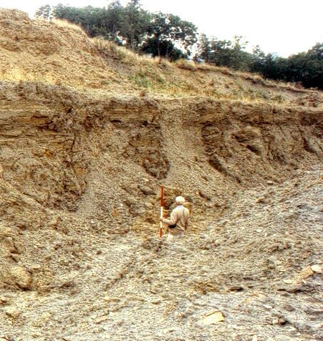
Although two small shaft minepits have been excavated and a number exposed in section (see picture) at Sharpthorne brickworks, no large Wealden minepit has ever been sectioned. It would be really nice to find a landowner prepared to allow such a dig. There is a problem with this idea: almost all known large (and indeed small) minepits are surrounded by trees whose roots would make cleaning and interpreting the sections rather difficult. If these problems could be overcome we might try and find out how big pits were managed, what happened to the spoil and whether we can find any evidence of seasonality in the mining activity.
In addition to formal excavation there are ironworking residues on the surface in many of the places referred to. Collecting samples for identification and mapping their distribution will be a key part of the programme.
Judie English, Brian Herbert, Roger Houghton, Jonathan Prus, Bob Turgoose
Goto: Summary Time Line References to Technology and Location References to People Maps Discoveries Photos